KASHMIR GREAT LAKES TREK
7 days · 8 alpine lakes · 65 km — India's best summer trek from Sonamarg to Naranag. Organized by HTT Adventures.
Enquire / BookOverview
TREK AT A GLANCE
Kashmir Great Lakes Trek is widely regarded as the best summer trek in India — the most famous and sought-after of all Himalayan treks. The trek winds through jungles, meadows, gullies, and vast high-altitude grasslands, passing 8 turquoise alpine lakes set in lush valleys. It is also popularly known as the 7 Lakes of Kashmir Trek.
| Detail | Info |
|---|---|
| Duration | 7 Days / 6 Nights |
| Distance | 65 KM |
| Maximum Altitude | 4,200 M (Gadsar Pass) |
| Difficulty | Moderate to Difficult |
| Start Point | Sonamarg (Shitkadi Base Camp) |
| End Point | Naranag Village |
| Best Season | June – Early October |
Why this trek
TREK HIGHLIGHTS
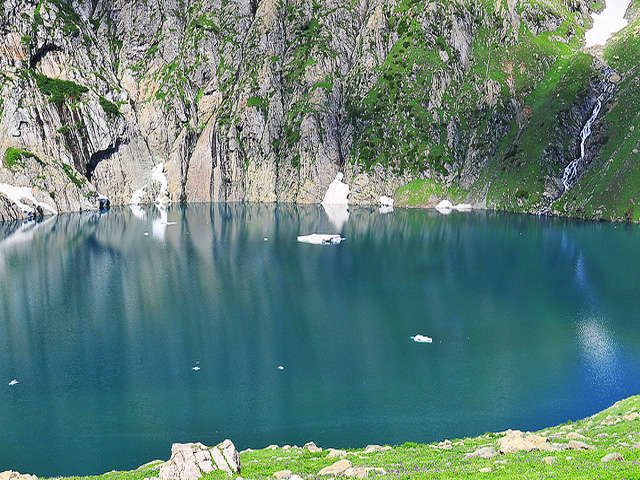
- ✓8 stunning turquoise alpine lakes including Vishansar, Kishansar, Gadsar, Satsar (7 lakes), Nundkol, and Gangabal
- ✓Panoramic views from three high-altitude passes: Nichnai Pass, Gadsar Pass (4,200m), and Zajibal Pass (4,000m)
- ✓Wildflower-filled meadows of Gadsar and Satsar valleys
- ✓Camping beside glacier-fed lakes with Mount Harmukh as backdrop
- ✓Trout fish visible in nearly every lake and river stream
- ✓Village cultural experience in Naranag
Fitness
DIFFICULTY ASSESSMENT
Kashmir Great Lakes Trek is moderate to difficult. Key challenges include:
- Three mountain passes with sharp ascents and descents
- Longest and toughest day: Day 4 (Vishansar to Gadsar via Gadsar Pass at 4,200m)
- Toughest descent: Day 7 (steep ~1,000m drop through jungle to Naranag — hard on knees, ankles, and toes)
- Boulder-hopping sections, river crossings (log bridges or fording), and slippery trails in rain
- Trek becomes more challenging during rainfall (especially July), when trails become blurry or disappear
If you are living a sedentary or non-active lifestyle, physical preparation (gym/cardio) is strongly recommended before undertaking this trek.
Route
SHORT ITINERARY
| Day | Route | Altitude | Distance | Time |
|---|---|---|---|---|
| Day 1 | Srinagar → Sonamarg (Shitkadi) | 2,730 m | Drive | ~3 hours |
| Day 2 | Sonamarg → Nichnai | 2,730 m → 3,505 m | 9 km | ~6.5 hours |
| Day 3 | Nichnai → Vishansar Valley | 3,505 m → 3,650 m | 13 km | ~5.5 hours |
| Day 4 | Vishansar Valley → Gadsar | 3,650 m → 3,810 m (via 4,200 m Gadsar Pass) | 14 km | ~8 hours |
| Day 5 | Gadsar → Satsar | 3,810 m → 3,600 m | 12 km | ~5 hours |
| Day 6 | Satsar → Gangabal | 3,600 m → 3,587 m | 9 km | ~5 hours |
| Day 7 | Gangabal → Naranag | 3,587 m → 2,271 m | 13 km | ~6.5 hours |
Daily breakdown
DETAILED DAY-BY-DAY ITINERARY
Srinagar to Sonamarg (Shitkadi Base Camp)
Drive from Srinagar to the base camp at Shitkadi, Sonamarg. The road winds through villages, farmlands, and mountain ranges alongside the shimmering Sindh River. The night is spent camping at Shitkadi for acclimatization. Your trek leader will brief you on the full itinerary. Welcome drinks, evening snacks, and dinner are served on arrival.
Sonamarg to Nichnai
The first trekking day begins with a gradual ascent. First stop: Tabletop, a beautiful plateau open towards the Thajwas Mountain Range with a panoramic view of the entire Sonamarg area — the famous Amarnath Peak is also visible from here. The trail continues through jungle patches, river canals, and rocky sections dotted with maple, birch, and pine trees. There is one river stream crossing assisted by trek leaders. The campsite at Nichnai is a valley of flowers with a stream running beside it.
Nichnai to Vishansar Valley
The day begins with a packed lunch provided after breakfast. First rest stop: Nichnai Pass — a steady ascent with rocky, steep descent on the other side into a wildflower meadow. Mountains stretch to both left (rugged) and right (snow-peaked). The trail leads to the Vishansar Valley campsite, located beside the river streams that originate from Vishansar Lake. Trout fish are visible in the river — note that fishing requires a proper license from the Fisheries Authority of Kashmir and is otherwise forbidden.
Vishansar Valley to Gadsar
Longest and toughest day of the trek. An early start is essential.
Within the first hour, you'll reach the iconic twin lakes — Vishansar and Kishansar Lakes — famous for their vivid blue water, abundant multi-coloured trout, and religious significance. Both lakes drain into the Kishanganga River running through Gurez valley. After the lakes, a steep 2-hour ascent leads to Gadsar Pass (4,200 m) — the highest point of the trek and the spot for most iconic trek photographs. After rest and photos, a steep and long descent follows, leading into the colourful Gadsar Meadow filled with wildflowers and herbs. Shortly after the meadow, Gadsar Lake appears on the left — a quiet, turquoise, least-visited lake. Local legend says its water and fish have healing powers. The campsite is a short walk from the lake.
Gadsar to Satsar
The easiest day of the trek. After about an hour of ascent, the trail opens to Satsar Meadow — a mostly flat, pleasant walk. The valley holds seven alpine lakes (the Satsar Lakes), and you'll pass by some of the finest. The seven lakes are among the sources of the famous Wangath River. The campsite is beside a river stream.
Satsar to Gangabal
The day starts with boulder and rocky terrain — expect a lot of hopping from boulder to boulder. The trail ascends to Zajibal Pass (4,000 m) over about 3 hours, followed by an equally long descent. On the way, you'll pass the biggest of the Satsar Lakes. From the pass, the first dramatic view of the twin Gangabal Lakes — Nundkol and Gangabal — unfolds. The descent leads through a narrow meadow and rolling terrain to the campsite beside Nundkol Lake, with the majestic Mount Harmukh as backdrop. Gangabal Lake is about 25 minutes from Nundkol. Both lakes are glacial and fed by Mount Harmukh's glaciers, and are rich in trout fish.
Gangabal to Naranag
The final day begins with an early morning start after breakfast. The first section is a gradual descent through the Trunkhol Meadow — lush, wavy grasslands dotted with yellow flowers and shepherd mud-and-brick houses where you can stop for local tea. After Trunkhol, the trail enters a dense jungle. After about 30 minutes you reach Butsheri Top, from where a steep 3-hour descent begins — the hardest descent of the entire trek, very taxing on knees, ankles, and toes. Tie laces tight; high-ankle shoes and knee caps are strongly recommended. The trek ends at Naranag Village.
Season
BEST TIME TO VISIT
The best months are June through early October. The trek remains closed during winter due to heavy snowfall that makes the high passes inaccessible for porters and ponies. After October, temperatures drop significantly and snowfall makes the trek impossible.
- June: Snow still covers upper reaches; meadows are fresh and green; lakes are clean with some ice
- July–August: Peak summer; most vibrant wildflowers; rain is possible especially in July
- September–October: Clear skies, stable weather; October is the last feasible month
Getting there
HOW TO REACH
By Air
Srinagar Airport is connected to all major Indian cities. The most convenient connection is from New Delhi. From Srinagar, it's a 3-hour drive to the base camp at Shitkadi, Sonamarg.
By Train
Kashmir does not have a rail connection to the rest of India. The nearest major railway station is Jammu, which is well-connected to all major Indian cities. From Jammu, travel to Srinagar by road.
By Bus / Road
Srinagar is connected via NH-1 highway. Regular buses and cabs run from Jammu to Srinagar (approximately one full day of travel). From Srinagar, it's a 3-hour drive to the base camp.
Prepaid SIM cards do not work in the Union Territory of Jammu & Kashmir. Carry your original ID proof and 2 photocopies.
What's included
PACKAGE INCLUSIONS & EXCLUSIONS
Inclusions
- •All vegetarian meals during the trek (breakfast, packed lunch, evening snacks, dinner)
- •Camp accommodation in high-quality tents (double-sharing basis)
- •Sleeping bags, sleeping mattresses, dining tents, and cutlery
- •Mountaineering-qualified and experienced trek leaders, guides, and cooks
- •All necessary mountain medicine: first aid kit, oxygen cylinder, etc.
- •All passes and permits
Meal plan
Breakfast: Eggs, paratha, chana, poha, dalia, upma, cornflakes, bread toast, butter, jam, roti, coffee, tea, kehwa, etc.
Lunch & Dinner: Veg biryani, veg pulao, mutter paneer, palak paneer, aloo gobi, rajma chawal, rajma kadhai, mix veg, chana masala, kadhi chawal, dal makhni, bhindi masala, dal fry, veg korma, Kashmiri haakh, aloo matar, baingan ka bharta, dam aloo, anda burji, etc. (served with different pickles and salad; both roti and rice available)
Evening Snacks: Tea, pakoda, soup, noodles, Maggi, veg rolls, biscuits, etc.
Desserts: Gulab jamun, phirni, halwa, custard, sewaya, fruit chaat, fruit cake, almond cake, etc.
Exclusions
- •Lunch on the first day
- •Personal expenses
- •Anything not specifically mentioned in the inclusion list
- •Offloading charges
- •Transportation (unless specified)
Packing list
THINGS TO CARRY
Trek Essentials
- • Backpack with rain cover
- • Trekking shoes (high-ankle preferred)
- • Day pack (for on-trek essentials: lunch box, water bottle, sunglasses, sunscreen, protein bars)
- • Headlamp / torch
- • Trekking pole
- • Personal medical kit
Clothing
- • Thermals
- • Fleece jacket
- • Down feather jacket
- • Waterproof pants
- • Sun cap
- • Woollen cap
Toiletries & Personal
- • Sunscreen
- • Lip balm
- • Toilet paper
- • Hand sanitiser
- • Toothbrush & toothpaste
- • Hand towel
- • Sanitary napkins (if required)
Your safety
SAFETY INFORMATION
Altitude Sickness
The trek has an altitude gain of approximately 2,000 m. The itinerary is designed over 7–8 days specifically to allow proper acclimatization. The highest point (Gadsar Pass) is only reached on Day 4, by which time the body is well-acclimatized. Stay well-hydrated: drink water frequently even when not thirsty. Walk at a slow, steady pace with small steps. If you experience headache, nausea, or any altitude sickness symptoms, immediately inform your trek leader.
Exit Points
If you feel unwell and cannot continue, the ideal time to exit is before or at the Vishansar campsite (Day 3). Once you cross Gadsar Pass (Day 4), you are near the middle of the trek and evacuation becomes more difficult (though not impossible). Nearest hospital from base camp: ~4 km at Sonamarg market.
Weather
Mostly sunny in summer; rain mostly in July. Rain makes trails slippery and sometimes causes paths to disappear — follow trek leader instructions strictly. Roping may be used if required during difficult rainy-day ascents/descents.
Swimming
Swimming in the lakes is permitted only for seasoned swimmers. The lakes are glacier-fed and cold. Trekkers must take care not to pollute these pristine water bodies.
COVID & Hygiene
All staff are COVID-tested; only COVID-negative staff accompany groups. All equipment sanitized before the trek. Trek leaders carry oxygen cylinders, medical kits, and COVID RAT kits. Extra sleeping bags and tents available for quarantine if required. Strict leave-no-trace policy followed at all campsites.
Common questions
FAQs
Enquire or book
GET IN TOUCH
For bookings, fixed departure dates, and custom groups for the Kashmir Great Lakes Trek, get in touch with us: